


3D reconstruction
Accurate, scalable
3D volume measurements
from satellite imagery
KAYRROS proprietary technology
Kayrros has developed proprietary technology based on photogrammetry techniques to obtain accurate, scalable 3D volume measurements from high-resolution satellite imagery. This affordable and reliable technology is already used across industries for topographic and inspection applications.
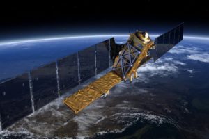
Skysat
Operator: Planet
Number of Satellites: 15 Sensor
Sensor Type: Optical multi-spectral (Four Bands: R, G, B, NIR)
Revisit times: Up to 2x daily
Additional info :
![]() The satellites are tasked according to Kayrros command on specify location, frequency, and date range.
The satellites are tasked according to Kayrros command on specify location, frequency, and date range.
![]() Acquisition can be collected in stereo for 3D reconstruction with multiple images of the same point taken a few seconds apart.
Acquisition can be collected in stereo for 3D reconstruction with multiple images of the same point taken a few seconds apart.
Coverage: Global Resolution: 72cm
Launch: 2014
Related Use Cases:
![]() Inventory Intelligence Read more
Inventory Intelligence Read more
![]() Metals and Minerals Stockpile Monitoring
Metals and Minerals Stockpile Monitoring
![]() Waste Management Operations
Waste Management Operations
![]() Right of Way Monitoring
Right of Way Monitoring
![]() Other Satellite constellations available on request
Other Satellite constellations available on request
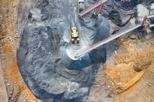
Use case
3D mine Monitoring
Mine operators simplify planning by leveraging a complete 3D model of their site, monitoring it constantly with the most recent 3D models
to take informed decisions and manage their operations. Users save time and resources by using an automated satellite-derived solution for all sites, and especially for remote sites.
Source: Kayrros
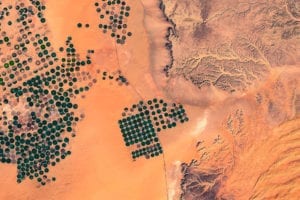
Satellite imagery
is much more than just pictures from space.
The Kayrros Asset Observation Platform enables industries to leverage satellite technologies across virtually all sensors available—including radar, hyperspectral, and 3D—to deliver actionable insights at scale.
Accuracy
Accuracy comparable to drones with less than a 1,2% difference in volume measurement
Scalability
Easy deployment to hundreds of sites globally with consistent methodology
Cost
Typically 10 times less expensive than drone monitoring
Our other satellite technologies
![]() Sentinel-1 Satellite Data
Sentinel-1 Satellite Data
Kayrros technologies leverage the full extent of the European Space Agency’s Sentinel-1 data to provide accurate……. Read more
![]() High-Resolution Data
High-Resolution Data
As a pioneer in the use of SAR data for commercial usage, Kayrros has developed a full range of technologies……. Read more
![]() Sentinel-2 Satellite Constellation
Sentinel-2 Satellite Constellation
Sentinel-2 provides a unique base to build large-scale monitoring systems through Kayrros Studio……. Read more
![]() Planetscope Imagery
Planetscope Imagery
Planetscope data represent today’s best trade-offs in resolution (3m), revisit frequency……. Read more
Recent posts
May

China Crude Demand Rebounds as the Rest of Asia Reels from COVID-19
China and its neighboring Asian countries are exhibiting different crude demand profiles just a few months after the first cases of...
Are Global Oil Stocks at a Turning Point?
Kayrros leverages satellites to provide comprehensive, realtime and...
01
May
Demand in COVID-19: Eliminating the blind spots
Shedding light on the impacts of COVID-19 on commercial and...
7
May
China Crude Demand Rebounds as the Rest of Asia Reels from...
China and its neighboring Asian countries are exhibiting different...
01
May
Want to be the first to know when oil prices will go up?
Kayrros leverages satellites to provide comprehensive, realtime and...
01
May
Demand in COVID-19: Eliminating the blind spots
Shedding light on the impacts of COVID-19 on commercial and...
7
May
Too Full or Not Too Full: The Cushing Paradox
The oil market was shaken to its core when NYMEX WTI prompt contract...
01
May
Want to be the first to know when the oil market reaches a...
Kayrros leverages satellites to provide comprehensive, realtime and...
01
May
Demand in COVID-19: Eliminating the blind spots
Shedding light on the impacts of COVID-19 on commercial and...
5
May
International Society of Photogrammetry and Remote Sensing...
Kayrros is very pleased to announce that six scientific research...
01
May